The 500-Meter Tsunami We Barely Noticed: A Reckoning for Our Remote Monitoring Tech
- Tech
Arjun Vedanta
- 0
- 7 minutes read
When the Earth Roared, and Nobody Heard
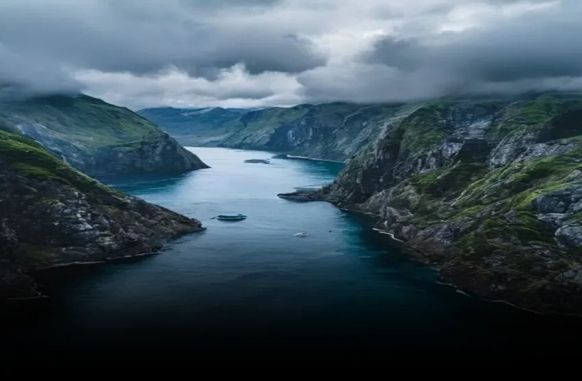
Let’s talk about a quiet morning in Alaska. August 10, 2025, 5:26 AM local time. Most of us were asleep, or maybe just brewing coffee. But in Tracy Arm fjord, something utterly biblical happened. A chunk of rock – at least 63.5 million cubic meters of mountain – sheared off, plunging into the glacial depths. This wasn’t just a big splash. This was a geological exclamation point, a sudden, violent displacement of water that created a breaking wave 100 meters high. It tore across the fjord at 70 meters per second, then slammed into the opposite shoreline, surging up the steep rock faces to a dizzying 481 meters above sea level.
Almost 500 meters. Think about that. That’s higher than the Empire State Building. Higher than any skyscraper in London. This wasn’t some slow-motion geological event; this was instantaneous, catastrophic energy release. Aram Fathian, a University of Calgary researcher, put it starkly: “It was the second highest tsunami ever recorded on Earth.”
And yet, as he notes, “until now, almost nobody heard about it.”
A near-miss. No injuries, no fatalities. Why? Pure luck. It happened before dawn, in a sparsely populated tourist area. But the silence surrounding such an immense event, one that easily could have obliterated anything in its path, should give us pause. It should make us ask some hard questions about how we’re watching our planet, especially as the climate shifts the very ground beneath our feet.
Our Digital Blind Spots: Where Was the Early Warning?
What I find truly fascinating here, and frankly, a bit disturbing, isn’t just the power of nature. It’s the sheer lack of real-time awareness around an event of this magnitude. In an era where we can track our heart rates, order groceries with a voice command, and stream 8K video from space, how did we miss a tsunami that climbed half a kilometer up a cliff?
This isn’t to say nothing was detected. Post-event analysis, often using high-resolution satellite imagery and digital elevation models like those derived from LiDAR scans, can reconstruct these events with impressive detail. Teams pour over before-and-after data, comparing topographical changes down to sub-meter accuracy to calculate rock volumes and displacement. Geodesy and remote sensing have made incredible strides. But that’s forensics, not forecasting.
The problem lies in the infrastructure – or lack thereof – for proactive, localized monitoring in truly remote, rugged environments. Deploying robust, autonomous sensor networks in places like Tracy Arm isn’t just expensive; it’s an operational nightmare. We’re talking about edge computing devices needing to withstand extreme cold, transmit data through challenging satellite links or custom mesh networks, and have multi-year battery lives without human intervention. The cost-benefit analysis often tilts against comprehensive, real-time coverage for areas deemed low-risk due to sparse population.
I’ve watched companies try this before. Remember the early 2000s push for ubiquitous environmental IoT? The hype was enormous. But the reality of power management, data reliability, and sheer maintenance in the field often buried those ambitions. For every breakthrough in sensor miniaturization or low-power wide-area networks (LPWANs), there’s still the brutal economics of physical deployment and long-term data ingestion. Nobody’s talking about the real problem, which is sustaining infrastructure in places where there’s no immediate commercial return.
The Climate Amplifier and the Unseen Pressure Points
When Mountains Move: The Glacial Connection
This isn’t an isolated incident. Landslide tsunamis, while localized, are often far more violent than their earthquake-generated cousins. We’ve documented 27 such events with runups exceeding 50 meters since 1925, with Lituya Bay in 1958 holding the grim record at 530 meters. What’s different now, however, is the accelerating pace of climate change.
Glacial retreat, accelerated by rising global temperatures, exposes unstable rock slopes. Permafrost melts, losing its structural integrity. The very foundations of mountains in places like Alaska are changing. This means areas previously considered stable are becoming ticking time bombs for future events. The South Sawyer Glacier, at the terminus of which this landslide occurred, has been retreating significantly for decades. That matters.
So, the technical challenge isn’t just about detecting a single event, it’s about monitoring an entire, dynamic landscape that is undergoing rapid, fundamental change. Predictive modeling for slope stability, which uses a cocktail of geological data, seismic readings, and real-time weather inputs, becomes exponentially harder when the underlying assumptions about stability are constantly shifting. Even advanced machine learning algorithms trained on historical data struggle with truly novel conditions, and these melting, shifting landscapes represent exactly that.
The human cost of this neglect isn’t theoretical. Imagine if that 2025 Tracy Arm tsunami had hit just a few hours later, when tour boats were cruising the fjord or hikers were on the shore. The consequences would have been devastating, potentially wiping out entire groups with no warning. We rely on these remote regions for tourism, for resource extraction, for scientific research. Our lack of robust monitoring in these critical, increasingly unstable zones is a hidden liability.
Learning (and Forgetting) in a Noisy World
The detailed reconstruction by Fathian’s team, published in Science, is a triumph of scientific inquiry. It shows what we can know, retrospectively. But the gap between what we can reconstruct and what we can predict or warn against in real-time remains vast. We’re great at post-mortems. Not always so great at prevention.
There’s a natural tendency in tech to chase the next big thing – the AI model that will predict *everything*. But sometimes, the critical need isn’t for a more sophisticated algorithm, but simply for more eyes and ears on the ground. Or, in this case, more durable, interconnected sensors, consistently deployed and diligently maintained. That’s the hard, unglamorous work of true predictive analytics, not just flashy dashboards.
We’ve seen cycles of alarm and neglect before, whether it’s earthquake early warning systems that never quite scale, or ambitious climate monitoring initiatives that run out of funding. This near-miss in Alaska is a stark reminder that even as our digital capabilities grow, the raw, unpredictable power of the planet is still very much in charge. And until we commit to sustained, foundational investment in monitoring the places we don’t often see, we’re betting on luck every time a mountain decides to move.