When a Mountain Falls: Alaska’s Silent Megatsunami and Our Imperfect Tech Watch
- Artificial Intelligence
Arjun Vedanta
- 0
- 6 minutes read
The Roar That Almost No One Heard
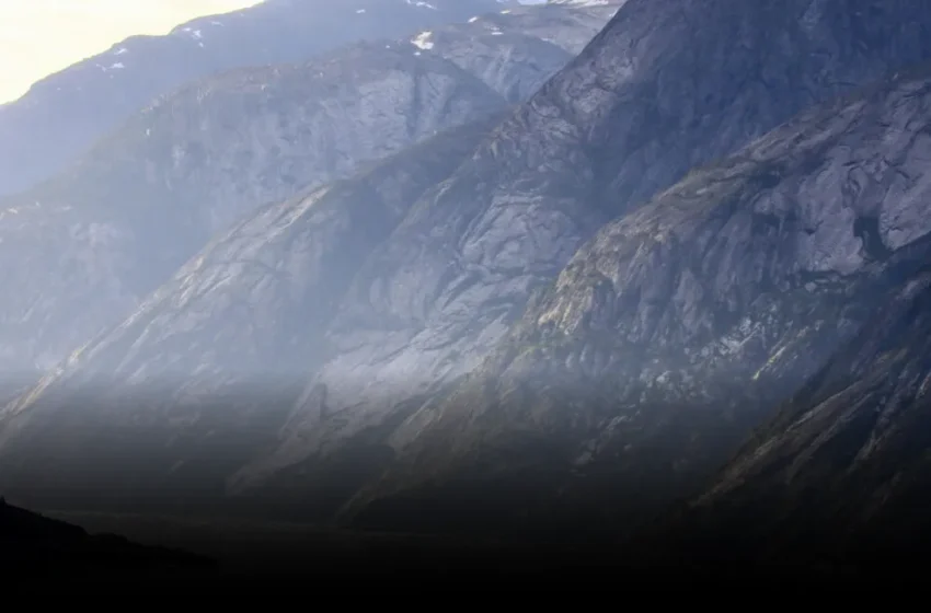
It was 5:26 AM on August 10, 2025. A date and time that, for most of the world, passed unnoticed. But in the remote, majestic solitude of Alaska’s Tracy Arm fjord, a mountain began to die. A colossal wedge of rock, some 63.5 million cubic meters of it — enough material to bury a small city — detached from its ancient perch. It plummeted into the deep, frigid waters at the terminus of the South Sawyer Glacier.
The impact was almost unfathomable. A breaking wave, initially 100 meters high, tore across the fjord at speeds exceeding 70 meters a second. When that aquatic behemoth slammed into the opposite shoreline, it didn’t just splash; it surged, climbing an astonishing 481 meters above sea level. Think about that: a wave nearly half a kilometer high. Aram Fathian, a researcher from the University of Calgary, a co-author of the recent Science study detailing this, put it bluntly: “It was the second highest tsunami ever recorded on Earth.”
What I find fascinating here is the ‘near-miss’ narrative. No injuries, no fatalities. It happened in the pre-dawn quiet, far from the summer tourist boats that frequent these spectacular waterways later in the day. Until Fathian and his team reconstructed it, almost nobody knew. It was a ghost event, a terrifying testament to nature’s raw power, witnessed only by rock and ice. But it raises a chilling question: what happens next time, when the fjord is full of people, or worse, critical infrastructure?
The Digital Lens: Reconstructing the Unseen
Let’s be honest about this: we’re getting better at *seeing* the past, even when it’s destructive. The reconstruction of this Tracy Arm event wasn’t done with eyewitness accounts (there were none) but through the painstaking analysis of geophysical data. This is where the tech angle truly emerges. Scientists didn’t just stumble upon this; they reverse-engineered a catastrophe using the digital breadcrumbs left behind.
Think about the toolkit involved: high-resolution satellite imagery captured before and after the event, revealing the scar on the mountainside and the altered landscape. Seismic sensors, perhaps hundreds of miles away, picking up the distinct rumble of millions of tons of rock hitting water. These passive data streams, often collected for other purposes, become the forensic evidence for Earth’s tantrums. I’ve watched companies try to make sense of disparate datasets for decades, from early GIS systems to today’s AI-driven geospatial analytics platforms. The ability to fuse these data points — satellite-borne Synthetic Aperture Radar (SAR) data for ground deformation, bathymetric lidar for underwater topography, optical imagery for surface changes — is a profound leap.
The implications are clear: we now have a global network of sensors, both terrestrial and orbital, that are constantly monitoring our planet. The challenge isn’t necessarily data collection anymore, though that remains complex in remote Alaskan fjords. The real hurdle is often the processing, the analysis, and the ability of algorithms to spot the needle in the haystack — a subtle shift, a pre-failure deformation that might hint at an impending event. (And yes, that’s as hard as it sounds when dealing with inherently chaotic systems).
Predictive Dreams and Harsh Realities
Landslide tsunamis, as the researchers noted, are often far more localized yet significantly more violent than their earthquake-generated cousins. We’ve seen 27 documented events with runups over 50 meters since 1925, topped by the legendary 1958 Lituya Bay tsunami at 530 meters. These aren’t just big waves; they are instantaneous, devastating displacements of water. The economics are brutal. We’re talking about regions that are increasingly valuable for tourism, resource extraction, and even strategic infrastructure like trans-Arctic fiber optic cables.
So, the obvious question arises: can we predict these things? Can AI sift through years of satellite data, seismic tremor patterns, and even weather-induced ground saturation models to flag areas at high risk? Companies like Planet Labs are imaging almost the entire Earth daily, and the raw data exists to feed these predictive models. The global disaster management technology market, projected to reach nearly $300 billion by 2030, is betting heavily on this kind of foresight.
However, let’s inject a dose of skepticism. Predicting *when* a massive, low-probability event will occur in a specific, remote location remains incredibly difficult. AI is fantastic at finding patterns in large datasets, but the training data for these megatsunamis is, thankfully, sparse. We’re often building models based on a handful of historical events, not millions. This isn’t like predicting stock prices or customer churn; it’s about geological forces acting on scales that defy easy categorization. And then there’s the ‘last mile’ problem: even if we could predict it, how do you reliably warn people in an isolated fjord at 5:26 AM?
The Unseen Costs and Unsolved Problems
Nobody’s talking about the real problem — which is less about the technical capacity to *monitor* and more about the economic and logistical capacity to *act*. Deploying and maintaining vast sensor networks in remote, harsh environments like Alaska requires immense capital investment and operational overhead. Who pays for that? And who decides which specific mountain slope gets real-time monitoring? The political will often only materializes after a disaster, not before.
We’ve been through hype cycles for every kind of predictive technology imaginable, from economic crashes to disease outbreaks. While our tools are undeniably more powerful today, the underlying complexity of natural systems hasn’t diminished. This Tracy Arm tsunami, a silent titan of an event, serves as a stark reminder. We can reconstruct, we can analyze, and we can develop increasingly sophisticated models, but our technological prowess, for all its advancements, still often leaves us reacting to nature’s whims, rather than truly mastering them. It’s a humbling thought, even for the most seasoned tech optimist.