
Europe’s Open Satellite Data: Wildfire Tracking Layer Reveals Deeper Shifts in Accountability
- Artificial Intelligence
Arjun Vedanta
- 0
- 4 minutes read
Open Data, Outsource Accountability
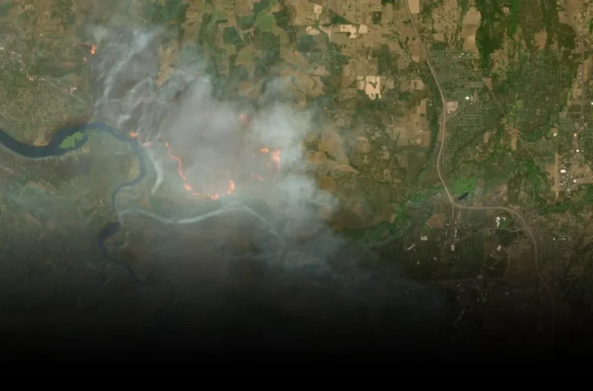
A new wildfire visualization layer, quietly launched on August 4 within Europe’s free Copernicus Browser, offers a potent tool for anyone with an internet connection to track active blazes and scorched earth from orbit. Built on nearly a decade-old underlying script, this integration of Sentinel-2 multi-spectral data provides an unprecedented, granular view—down to 10 meters resolution—of environmental catastrophe unfolding globally.
Yet, the enthusiasm surrounding such ‘democratized’ access often glosses over a more profound implication: free data, in this context, increasingly means outsourced accountability. The European Space Agency (ESA) and the European Union (EU) have delivered a powerful public good, but they’ve also subtly shifted the onus of interpretation and advocacy onto an already overburdened public.
This particular timing, amidst a record-setting global wildfire season, is hardly accidental. Highlighting the Copernicus Browser’s capabilities now serves as excellent public relations for the Earth observation program, allowing governmental bodies to appear proactive while channeling public pressure towards self-service monitoring rather than necessarily direct, large-scale intervention prompted by their own systems.
The Illusion of Actionable Intelligence for All
The technical capabilities of the Sentinel-2 mission are genuinely impressive. Its three satellites continuously scan the planet, feeding the Copernicus Browser with rich datasets that distinguish active fires (rendered in white or yellow) from burning vegetation (red) and recently charred landscapes (dark brown or black). This level of detail, available without cost, bypasses the traditional paywalls of commercial remote sensing providers like Planet Labs or Maxar.
But the mere availability of sophisticated geospatial intelligence does not automatically translate into actionable solutions for the average citizen, or even for under-resourced local authorities. Knowing a fire is spreading, or that a region has burned, is a critical first step. Acting on that information—mobilizing resources, evacuating communities, or implementing preventative measures—requires an entirely different infrastructure, one that raw satellite data alone cannot provide.
This is where the ‘decade-old script’ detail becomes particularly telling. It’s not a sudden technological breakthrough but a productization, a user-friendly wrapper around long-established analytical methods. The innovation here isn’t in the underlying science, but in its packaging and dissemination, suggesting a strategic move to distribute, rather than centralize, environmental data analysis.
Beyond Silicon Valley’s Blind Spots
From a global vantage point, particularly observing outside the Silicon Valley echo chamber, the implications of Europe’s Copernicus program resonate differently. US tech media often fixates on ‘disruption’ and the latest platform wars, frequently missing the quiet, foundational shifts happening in public sector innovation that aren’t driven by venture capital or IPOs.
The value of Copernicus lies precisely in its public funding and open access ethos, a counterpoint to the privatization trends seen elsewhere in data collection and analysis. However, this same ethos can create a peculiar structural implication: it democratizes data access but not necessarily the capacity for response.
Developing nations, or even cash-strapped municipalities within wealthier ones, might now have the ‘eyes in the sky’ they previously lacked. Yet, without the necessary ground infrastructure, emergency services, and political will to act on this newfound intelligence, the data remains just that—data. It underscores a persistent chasm between sophisticated public sector tools and the uneven global capacity to leverage them effectively for real-world impact.
The introduction of a user-friendly wildfire layer by Copernicus is undoubtedly a boon for researchers, journalists, and concerned citizens alike. However, it also serves as a stark reminder that while transparency in environmental data is vital, it cannot be mistaken for a comprehensive solution. The responsibility for addressing global crises like wildfires extends far beyond merely providing the tools to observe them; it demands coordinated, resourced, and accountable intervention from the institutions that wield the most power.
